


Data Analytics | Data Engineering | Enterprise GIS | GeoAI | Machine Learning
I design secure, explainable, and governance-aware data systems that transform complex spatial, public-health, and enterprise data into trusted intelligence. My work combines data analytics, data engineering, enterprise GIS, spatial analysis, machine learning, cloud computing, and secure software engineering to support practical decision-making.
MSc Big Data Technologies Candidate · M.Tech. Geoinformation Science and Remote Sensing · 10+ years of professional experience · 10+ peer-reviewed publications
| Measure | Impact |
|---|---|
| Experience | 10+ years across GIS, data analytics, public-health intelligence, and spatial decision support |
| Delivery | 6,000+ maps, dashboards, and analytical products |
| Capacity building | 100+ professionals trained in GIS, spatial analysis, and digital data collection |
| Research | 10+ peer-reviewed scientific publications |
| Public service | National-level public-health surveillance and emergency-response support in Liberia |
A working research prototype that transforms aggregated district-level data into outbreak-risk classifications, spatial intelligence, explainable model outputs, and dashboard-based public-health decision support.
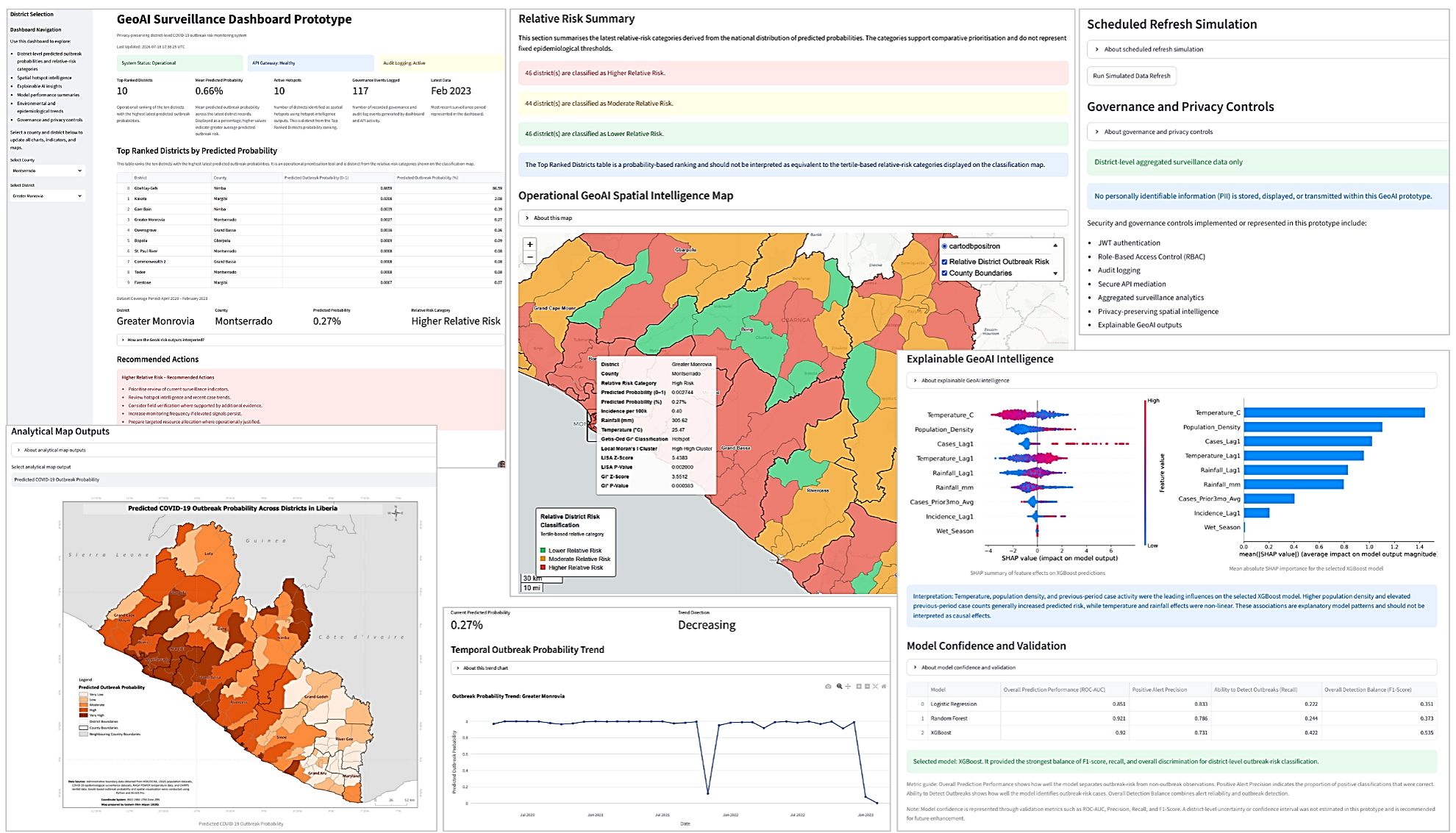
- XGBoost outbreak-risk classification
- Getis-Ord Gi* hotspot analysis
- Local Moran's I cluster and outlier analysis
- SHAP-based model explanations
- Interactive Streamlit and Folium dashboard
- Secure FastAPI gateway
- JWT authentication and role-based access control
- Audit logging and governance monitoring
- Docker-based application packaging
- AWS prototype API deployment and Streamlit Cloud dashboard deployment
Technology stack: Python GeoPandas PySAL Scikit-learn XGBoost SHAP FastAPI Streamlit Folium Docker AWS JWT RBAC
Data architecture: The public demonstration uses CSV and GeoJSON data. The production-oriented architecture incorporates PostgreSQL/PostGIS as the scalable spatial database layer.
Explore the project:
- Live Dashboard: Open dashboard
- Source Repository: View on GitHub
- Secure API Documentation: Request authorised academic access by email
This system is an academic research prototype. It is not intended for clinical diagnosis or operational public-health deployment without further validation, security hardening, governance review, and institutional approval.
- Data analytics and dashboard-driven decision-support systems
- Data engineering and ETL/ELT workflows
- Enterprise GIS, spatial data management, and geospatial infrastructure
- GeoAI, spatial machine learning, and explainable AI applications
- Secure APIs and cloud-enabled intelligence platforms
- Research software and reproducible technical artefacts
Explore additional work in data engineering, machine learning, enterprise GIS, public-health GeoAI, cloud security, automation, and reliability engineering:
- Portfolio Repository: View source projects
Data Analytics and Engineering: Python SQL Pandas NumPy PostgreSQL PostGIS ETL/ELT Data Validation Feature Engineering Spark PySpark Hive
GeoAI and Enterprise GIS: ArcGIS Pro ArcGIS Online QGIS GeoPandas PySAL Spatial Statistics Moran's I LISA Getis-Ord Gi* Hotspot Analysis Cartography Remote Sensing
Machine Learning and Explainable AI: Scikit-learn XGBoost Random Forest Logistic Regression SHAP Model Evaluation Spatial Machine Learning Responsible AI
Cloud, APIs, and Secure Systems: FastAPI REST APIs Docker AWS Streamlit Git/GitHub JWT RBAC Audit Logging API Security Privacy-Preserving Analytics
Over the past decade, I have supported enterprise GIS, spatial data management, public-health surveillance, emergency response, and analytics across research and operational environments.
My professional work includes:
- Enterprise GIS implementation and spatial data infrastructure
- Public-health surveillance and outbreak response
- COVID-19, malaria, measles, cholera, mpox, and Lassa fever intelligence
- Dashboard development and operational reporting
- GIS training and capacity building
- Geospatial data quality assurance and automation
- Applied research in spatial epidemiology and public-health analytics
Design and Evaluation of a Privacy-Preserving GeoAI Health Surveillance System Using a Hybrid Cloud Architecture
Submitted for assessment as part of the MSc Big Data Technologies programme.
Using Design Science Research, I designed, implemented, and evaluated a governance-aware GeoAI public-health surveillance artefact across six dimensions:
- Predictive performance
- Spatial intelligence
- Explainability
- Security and governance
- Usability
- Decision-support value
The research demonstrates how aggregated and de-identified surveillance data can be transformed into actionable outbreak-risk intelligence while supporting transparency, controlled access, and governance traceability.
University of East London / UNICAF
Final award pending
Coursework and research covering big data engineering, machine learning, cloud computing, cybersecurity, and intelligent data systems.
Federal University of Technology, Akure (FUTA), Nigeria / UN-ARCSSTEE
Specialised training in geographic information systems, remote sensing, spatial analysis, geospatial data management, cartography, and environmental modelling.
I have authored and co-authored 10+ peer-reviewed publications covering infectious-disease surveillance, spatial epidemiology, GIS, GeoAI, and public-health intelligence.
Google Scholar · ORCID · ResearchGate
My research complements my engineering work by translating analytical methods into practical, reproducible GeoAI and decision-support solutions.
- IBM Data Engineering Professional Certificate
- Microsoft Fabric and modern analytics engineering
- Cloud-native data engineering and lakehouse architectures
- GeoAI, spatial machine learning, and GeoFoundation Models
- Spatio-temporal AI and AI agents for spatial intelligence
- Cloud security and security monitoring
I am open to professional opportunities and collaborations involving data analytics, data engineering, enterprise GIS, GeoAI, machine learning, explainable AI, privacy-aware analytics, and public-health intelligence.
- LinkedIn: Godwin Etim Akpan
- GitHub: Jedidiah82
- Email: godwinea.ai@gmail.com
Committed to building secure, explainable, and practical data solutions that create measurable impact.